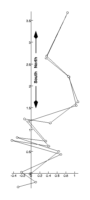
GPS data for the climb from La Sapienza to the top and back. The data was recorded on 1989-12-30 between 22:59:59 and 22:59:59. There are 20 data points recorded. The path length is 15.41Km, with a total climb of 883.0 m. Altitudes are measured in metres, all other distances in kilometres. The speeds are averaged over the last minute or the closest approximation to it.
3-Dimensional plot of the data.

| latitude | longitude | altitude | time | dist to 0 | path len | speed | x-coord | y-coord |
| 37ş 41' 12.93" | 14ş 59' 16.77" | 1633 | 22:59:59 | 0.00 | 0.00 | 0.00 | 0.00 | 0.00 |
| 37ş 41' 29.15" | 14ş 59' 42.80" | 1698 | 22:59:59 | 0.81 | 0.81 | 0.00 | 0.64 | 0.50 |
| 37ş 41' 39.43" | 14ş 59' 03.63" | 1753 | 22:59:59 | 0.89 | 1.82 | 0.00 | -0.32 | 0.82 |
| 37ş 41' 36.72" | 14ş 59' 30.59" | 1794 | 22:59:59 | 0.83 | 2.49 | 0.00 | 0.34 | 0.74 |
| 37ş 41' 51.55" | 14ş 59' 14.60" | 1853 | 22:59:59 | 1.21 | 3.10 | 0.00 | -0.05 | 1.19 |
| 37ş 42' 03.06" | 14ş 59' 59.25" | 1923 | 22:59:59 | 1.89 | 4.25 | 0.00 | 1.04 | 1.55 |
| 37ş 42' 24.31" | 14ş 59' 52.53" | 2087 | 22:59:59 | 2.42 | 4.94 | 0.00 | 0.87 | 2.21 |
| 37ş 42' 39.68" | 14ş 59' 31.37" | 2240 | 22:59:59 | 2.77 | 5.66 | 0.00 | 0.36 | 2.68 |
| 37ş 43' 11.81" | 14ş 59' 51.07" | 2516 | 22:59:59 | 3.87 | 6.80 | 0.00 | 0.84 | 3.67 |
| 37ş 42' 38.21" | 14ş 59' 30.90" | 2264 | 22:59:59 | 2.73 | 7.98 | 0.00 | 0.35 | 2.64 |
| 37ş 42' 24.69" | 14ş 59' 51.84" | 2080 | 22:59:59 | 2.42 | 8.66 | 0.00 | 0.86 | 2.22 |
| 37ş 42' 05.84" | 15ş 00' 00.80" | 2011 | 22:59:59 | 1.99 | 9.29 | 0.00 | 1.08 | 1.64 |
| 37ş 41' 50.16" | 14ş 59' 34.77" | 1913 | 22:59:59 | 1.26 | 10.10 | 0.00 | 0.44 | 1.15 |
| 37ş 41' 53.18" | 14ş 59' 10.43" | 1892 | 22:59:59 | 1.28 | 10.70 | 0.00 | -0.16 | 1.24 |
| 37ş 41' 33.01" | 14ş 59' 33.38" | 1888 | 22:59:59 | 0.78 | 11.54 | 0.00 | 0.41 | 0.62 |
| 37ş 41' 37.26" | 14ş 58' 58.77" | 1754 | 22:59:59 | 0.88 | 12.40 | 0.00 | -0.44 | 0.75 |
| 37ş 41' 26.91" | 14ş 59' 44.81" | 1732 | 22:59:59 | 0.82 | 13.58 | 0.00 | 0.69 | 0.43 |
| 37ş 41' 13.78" | 14ş 59' 07.73" | 1728 | 22:59:59 | 0.24 | 14.57 | 0.00 | -0.22 | 0.03 |
| 37ş 41' 06.36" | 14ş 59' 21.17" | 1724 | 22:59:59 | 0.25 | 14.97 | 0.00 | 0.11 | -0.20 |
| 37ş 41' 02.81" | 14ş 59' 04.48" | 1620 | 22:59:59 | 0.43 | 15.41 | 0.00 | -0.30 | -0.31 |